Venezuela Earthquakes 2026: The Structural and Economic Aftershocks of a 125-Year Record Event
The Venezuela earthquakes 2026 didn’t just shake buildings — they exposed every structural fault line the country has been quietly accumulating for decades. When you map this event against the historical seismic record and the current state of Venezuela’s infrastructure, you’re looking at more than just a natural disaster. It’s the collision of a geological inevitability with a man-made vulnerability crisis.
A magnitude 7.2 foreshock struck western Venezuela, followed about 40 seconds later by a 7.5 mainshock. The mainshock was the largest recorded earthquake to strike Venezuela, and the strongest in over 125 years. That context matters enormously — and it’s exactly what most coverage buries in paragraph 10.
What the Seismic Data Actually Reveals About the June 24 Event
An initial analysis by the USGS showed the first 7.2-magnitude earthquake was followed by a 7.5-magnitude quake only 39 seconds later. The USGS classified the earthquakes as a “doublet” — a pair of earthquakes that happen within a short time and distance from each other. Unlike a typical earthquake sequence, where significantly smaller aftershocks follow a larger earthquake, doublets are earthquakes of similar magnitude that are causally linked, but seismologically distinct.
This distinction is worth pausing on. In 2023, an earthquake doublet struck Turkey and Syria, measuring magnitudes of 7.8 and 7.7 — happening just 95 kilometres and nine hours apart, affecting 14 million people and causing widespread damage. Venezuela’s doublet compressed that same rare phenomenon into 39 seconds. The structural engineering implications are severe: buildings that might survive one major event rarely retain integrity for an immediate second impact of near-equal force.
The twin earthquakes originated in Yaracuy state, west of Caracas. The first, a magnitude 7.2 quake, struck at a depth of 22km, followed less than a minute later by an even larger magnitude 7.5 quake at a depth of about 10km. That shallow depth of the mainshock is critical — shallower earthquakes deliver more destructive energy to the surface. From an infrastructure analysis standpoint, that 10km depth is the engineering detail most casual reporting skips entirely.
In northern Venezuela, the Caribbean plate and South American plate interact along a complex plate boundary called the Boconó-Morón-El Pilar Fault System — a complex series of right-lateral strike-slip faults that developed in the late Tertiary, forming part of the transform plate boundary in the southern Caribbean. The Caribbean Plate moves eastward relative to the South American Plate at a rate of roughly two centimetres per year, continuously building stress within the Earth’s crust. Two centimetres per year sounds trivial. Over decades, it’s a loaded spring — and June 24 was the release.
The most catastrophic prior earthquake on the Boconó fault system occurred on March 26, 1812, causing widespread destruction in the cities of Mérida and Caracas and claiming an estimated 30,000 lives. That 1812 event is the benchmark Venezuela has been warned about repeating for generations. The 7.5 magnitude seismic event was the largest earthquake in Venezuela in more than a century — the only one larger was a 7.7 magnitude quake in October 1900.
Why Infrastructure Failure Amplified the Damage
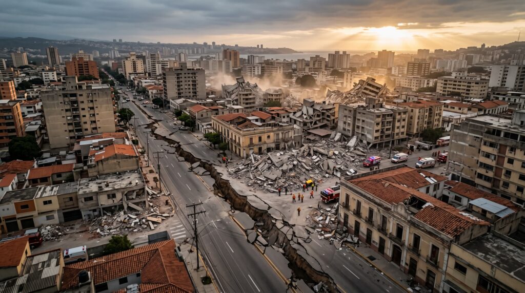
Here’s what the structural analysis makes clear: the geology didn’t act alone. The USGS warned that the death toll could rise significantly because many buildings in the affected region are made from unreinforced brick masonry and adobe, which are particularly vulnerable during strong earthquakes. This is the sentence that should be at the top of every policy discussion — not a footnote in a wire story.
Venezuela’s economy had already been crippled by years of US-led sanctions, hyperinflation, government corruption, and mismanagement of the oil sector, despite sitting on the world’s largest oil reserves. Its GDP had shrunk by roughly 80% since 2013. That economic collapse directly translated into deferred maintenance, aging building stock, and a public infrastructure system running on borrowed time. You don’t need to be an engineer to follow that logic — following years of economic devastation and underinvestment in public services, the country’s infrastructure, from hospitals to electricity and water, was ill-equipped to deal with a crisis like this.
Internet connectivity dropped sharply across Venezuela after the quakes damaged power and telecoms infrastructure, before recovering slightly in the hours afterward, according to watchdog NetBlocks. Simón Bolívar International Airport was damaged, and all flights departing from or arriving there were canceled. The airport closure isn’t just a travel disruption — it’s a humanitarian logistics bottleneck that slows every aid delivery that follows. The coastal state of La Guaira suffered the worst damage and has been declared a disaster zone — the area is home to one of the country’s largest seaports and Simón Bolívar International Airport, which serves the capital Caracas.
The type of sediment beneath Caracas amplifies seismic waves and enhances earthquake damage. This is a documented geophysical problem going back to a 1968 USGS report that documented, for the first time, short-period seismic wave ground-motion amplifications in the Caracas Valley. Venezuela has known about this vulnerability for nearly 60 years. The gap between knowing and building accordingly is where the real story lives.
The Economic Exposure: Numbers That Reframe the Scale
When you look at the financial modeling here, the numbers are arresting. The USGS PAGER service estimated a 39% probability of economic losses between US$10 billion and US$100 billion, and a 30% probability of economic losses exceeding US$100 billion, with upper estimates amounting to up to 20% of Venezuela’s GDP. For comparison, the upper figure of that range is roughly the size of the entire Venezuelan economy. That’s not a recovery scenario — that’s an existential economic event layered onto a country already in crisis.
Venezuela declared a state of emergency, with a high-level task force created to oversee search and rescue operations and an initial $200 million fund to rebuild the country. That fund, while meaningful as an immediate signal, sits at roughly 0.2% of the lower USGS economic loss estimate. The reconstruction gap is staggering. Venezuela’s earthquakes could open the path for more direct US investment to meet immediate needs, such as drinking water infrastructure, and in long-term reconstruction projects.
For more than a decade, Venezuela has faced a prolonged economic crisis driven by hyperinflation, alongside political instability and heightened insecurity. Millions of Venezuelans have been forced to leave the country, while more than a third of those who remain live in extreme poverty. This latest event is going to exacerbate existing inequalities and drive even more families into extreme hardship. From an analytical standpoint, the compounding of these pre-existing conditions onto a major seismic event is precisely the pattern we saw in Haiti in 2010 — and the reconstruction timelines there should inform every projection being made right now.
In my view, the most underweighted factor in current coverage is the aftershock sequence. USGS forecasts indicate a high likelihood of continued seismic activity in the coming days. In the first 24 hours after the main earthquake, scientists expect dozens of aftershocks of magnitude 4 or greater, with a high probability that at least one could exceed magnitude 5. Buildings already structurally compromised by the doublet are highly vulnerable to collapse in aftershocks, which means the infrastructure toll is almost certainly not finalized.
Final Word
When you step back from the immediate reporting and analyze the structural pattern here, the Venezuela earthquakes 2026 represent a convergence of predictable seismic risk and decades of infrastructure underinvestment. The geology was always going to deliver this event — the San Sebastián, El Pilar, and Boconó fault systems do not move continuously; instead, stress builds up over decades before being released in sudden ruptures. What wasn’t inevitable was the scale of the damage that followed.
The reconstruction path forward — for a country carrying an 80% GDP contraction, a political transition, and now a seismic catastrophe — will require sustained international coordination at a scale rarely seen in Latin America. For authoritative updates as the situation develops, you can follow the USGS Earthquake Hazards Program, the UN ReliefWeb Venezuela updates, and analysis from the World Vision emergency response briefing. For deeper historical seismic context, the USGS Quaternary Faults of Venezuela database remains the most complete structural reference available.
What you should take away from the Venezuela earthquakes 2026 isn’t just the magnitude numbers — it’s that the seismic risk was documented, the infrastructure vulnerability was documented, and the gap between those two facts is where the policy failure happened. That’s the pattern worth watching as reconstruction begins.
This article is an editorial synthesis of publicly available reporting and seismic data. Findings reflect conditions as of June 25, 2026, and may change as official assessments continue.
Frequently Asked Questions About Venezuela earthquakes 2026
What caused the Venezuela earthquakes in 2026?
The Venezuela earthquakes of 2026 were caused by seismic activity along the El Pilar fault system, one of the most active tectonic boundaries in South America, where the Caribbean and South American plates meet. The 7.2 and 7.5 magnitude events released enormous energy that had built up along this fault over decades. Venezuela’s northern coastal region sits directly above this fault line, making it one of the country’s most geologically vulnerable zones.
How much infrastructure damage did the 2026 Venezuela earthquakes cause?
The combined impact of both quakes resulted in billions of dollars in estimated infrastructure damage, affecting roads, bridges, pipelines, and residential buildings across the northeastern states. Venezuela’s aging infrastructure, already weakened by years of economic decline and deferred maintenance, was particularly vulnerable to the seismic stress of this magnitude. Structural engineers have warned that many buildings in Caracas and other urban centers were not built to modern earthquake-resistant standards.
How can residents prepare for future earthquakes in Venezuela?
Residents should secure heavy furniture to walls, prepare an emergency kit with water, food, and first aid supplies, and identify safe shelter spots in each room away from windows and exterior walls. It is also important to know your building’s construction date, as older structures may lack seismic reinforcement and carry a higher collapse risk. Local civil defense agencies recommend practicing earthquake drills and establishing a family communication plan in advance.
How do the 2026 Venezuela earthquakes compare to the 1812 Caracas earthquake?
The 1812 Caracas earthquake, estimated at around 7.7 magnitude, remains Venezuela’s deadliest seismic event, killing tens of thousands at a time when the population was a fraction of what it is today. While the Venezuela earthquakes of 2026 reached comparable magnitudes, modern seismic monitoring and earlier warning systems helped reduce immediate casualties. However, experts argue that Venezuela’s current urban density and infrastructure decay make a repeat of catastrophic 1812-level destruction increasingly possible without serious investment in earthquake preparedness.
Is it a myth that only coastal areas of Venezuela face a serious earthquake risk?
Yes, this is a common misconception. While the northern coastal zone near the El Pilar and San Sebastián faults carries the highest risk, seismic activity can affect inland regions, including Caracas, Mérida, and areas near the Andes, which sit along separate but active fault systems. Earthquake risk in Venezuela is a nationwide concern, not limited to the coast, and building codes need to reflect that reality across all urban centers.