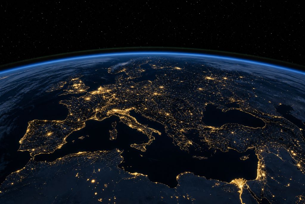
Imagine looking down at Earth from space after dark and seeing the entire story of human civilization written in light. That is exactly what NASA’s latest satellite imaging technology now makes possible — and the picture it paints is as revealing as it is stunning. From glittering megacities to vast stretches of darkness, a new generation of orbital observations is reshaping how scientists, planners, and everyday citizens understand our planet’s development in real time.
A Planet Illuminated: What NASA’s New Data Reveals
NASA has released an extraordinary new set of satellite imagery and mapping data that captures Earth’s artificial nighttime lighting in finer detail than anything seen before. These maps do far more than show where the lights are on — they tell the story of where people live, how economies function, and how rapidly the planet is changing.
By analyzing the intensity, distribution, and shifting patterns of artificial light across the globe, researchers can draw meaningful conclusions about human settlement, infrastructure growth, and economic activity — all from hundreds of miles above the surface. The reach of this technology is remarkable: no ground crews, no surveys, no direct observation required.
Brightest and Darkest: A World Divided by Light
One of the most striking takeaways from NASA’s new mapping effort is the sharp contrast between the world’s brightest and darkest regions when viewed at night.
- Brightest zones correspond closely with heavily urbanized, densely populated, and economically active regions. Major metropolitan corridors across North America, Europe, East Asia, and parts of South Asia glow intensely, reflecting not only population size but also energy consumption and commercial activity.
- Darkest regions tend to align with remote wilderness areas, sparsely populated territories, and parts of the world where infrastructure and economic development remain limited. Large swaths of central Africa, rural Asia, and polar regions appear nearly invisible from orbit after sunset.
- Transitional zones — areas that have shifted noticeably in brightness over recent years — are among the most scientifically interesting. These regions signal change, whether that change comes in the form of rapid urbanization, sudden economic disruption, or post-conflict recovery.
The ability to pinpoint these transitions with precision is what makes NASA’s updated monitoring systems such a powerful tool for global research.
Unprecedented Shifts: A Planet in Motion
Perhaps the most significant finding highlighted by this new research is that Earth’s artificial nighttime lighting is not static — it is volatile, dynamic, and changing in ways that carry real-world meaning.
NASA’s satellite systems can now detect and map these fluctuations with a level of accuracy that was simply not achievable in earlier generations of orbital observation. Regions that were once dark are brightening rapidly as urbanization accelerates. Other areas, particularly those affected by economic downturns or conflict, show measurable dimming over time.
This kind of time-lapse perspective on human civilization — watching the lights come on or go out across entire countries and regions — gives scientists a uniquely objective window into global development trends. It strips away the complications of self-reported statistics or politically influenced data, replacing them with raw, observable evidence from orbit.
Why Nighttime Light Data Matters Beyond the Maps
The implications of NASA’s nighttime light research extend well beyond the visual spectacle of glowing satellite images. This data has practical, high-stakes applications across a wide range of fields.
- Urban planning: City governments and regional planners can use nighttime light trends to track the pace and direction of urban sprawl, helping them anticipate infrastructure needs before they become critical.
- Economic analysis: Economists and development organizations use light intensity as a proxy for GDP activity, particularly in regions where reliable economic data is scarce or delayed.
- Disaster response: When natural disasters or conflicts disrupt power infrastructure, the sudden darkness that appears in satellite imagery can help emergency responders quickly identify the hardest-hit areas and prioritize aid.
- Environmental monitoring: Light pollution is a growing environmental concern, affecting wildlife migration, ecosystems, and human health. Tracking how artificial light spreads helps conservation efforts address these impacts more effectively.
- Energy policy: Governments working to expand electrification in developing regions can use NASA’s data to measure progress and identify communities that still lack reliable access to power.
The Technology Behind the View
Capturing Earth’s nighttime glow with this level of detail requires sophisticated instrumentation and careful data processing. NASA’s satellite sensors are calibrated to distinguish between different types of artificial light sources, filter out natural light phenomena such as moonlight and atmospheric glow, and isolate the specific signatures of human-generated illumination.
Over time, as more data is collected and analytical methods improve, the resolution and interpretive power of these maps continue to grow. What once required years of accumulated data to detect can now be observed over much shorter timeframes, allowing researchers to respond to changes as they happen rather than in retrospect.
This improvement in temporal resolution — the ability to see change over weeks or months rather than decades — is one of the most significant leaps forward in Earth observation science in recent years.
A New Way of Seeing Our World
There is something deeply compelling about the idea that the story of human civilization can be read from space, written in light against the darkness of a sleeping planet. NASA’s latest imagery and mapping initiative does exactly that, turning the simple presence or absence of artificial light into a rich, data-driven narrative about where humanity has been and where it is heading.
As these tools continue to evolve, they promise to give scientists, policymakers, and the public an ever-clearer picture of a world in constant flux. Whether tracking the explosive growth of a new megacity, the economic recovery of a war-torn region, or the slow creep of light pollution into once-pristine wilderness, NASA’s nighttime maps are redefining what it means to observe our planet.
The lights are on. And now, more than ever, we can see exactly what they are telling us.